5 MINUTES WITH MILAGROS MENÉNDEZ,
DIRECTOR OF THE SIERRA DE HUÉTOR NATURAL PARK
Why is this Natural Park so special?
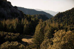
It is special because it is a mid-mountain park, very close to the city of Granada, with a very interesting variety of landscapes. The Natural Park brings together several mid-altitude mountain ranges crossed by steep ravines, streams and cliffs, which together form a complex relief. The carbonate nature of the materials (limestone and dolomite) in the park creates a typical karst landscape, represented by numerous formations such as lapiazes, dolomites, galleries, and caves. Associated with these materials are numerous springs, some of which have given rise to major rivers within the park, such as the Fardes and the Darro. These materials allow the development of pine forests, holm oak groves, oak forests, scrublands, and riparian forests, which are distributed throughout the park, forming a vegetation mosaic that is home to a diverse multitude of flora and fauna species.
The towns are home to a rich historical and cultural heritage, represented by the numerous attractions available to visit. It has an extensive network of forest trails and paths that allow visitors to explore almost the entire area and provide opportunities to explore the rich natural, scenic, ethnological, and cultural heritage while enjoying the sport of cycling.
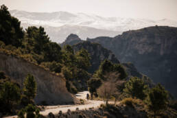
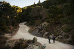
It is interesting, especially with regard to cycling tourism, that the Natural Park offers a significant network of bicycle-friendly routes and paths, extending across almost the entire protected area. This network includes routes within and outside the park perimeter, creating a coherent and connected network with the neighboring protected areas of the Natura 2000 Network, the Sierra Arana and Barrancos del Río Aguas Blancas, and with the population centers within its area of influence.
The total length of this cycling network is 223 km, of which 128 km are within the perimeter of the Natural Park. These public routes are supported by trails with different types of surfaces, including dirt roads, concrete paths and paved roads. The routes pass through the most characteristic and unique landscapes and resources of the Natural Park and approach the main public facilities in the protected areas.
What corner of the Sierra de Baza can’t we miss?
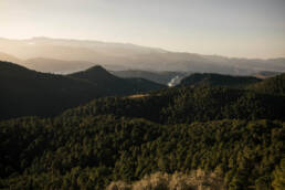
There are many very attractive spots, it’s not easy to highlight them all. I could mention, for example, the Fuente de la Teja, the source of the Darro River, or some trails, such as the Cañada del Sereno, which runs through the main ecosystems of the Natural Park, the Cerro de Majalijar, the highest peak in the Park, and also the Umbría de Víznar, where there is a very interesting Spanish fir forest, and the climb to the fire watchtowers, where there are viewpoints offering privileged views of the entire area and which are included in several public trails.
Also noteworthy is the Trench Route, which, over approximately 22 km, covers four of the main defensive positions in the area. This area was a frontline during the Civil War, and today, these structures serve as authentic lookout points, given their position, overlooking the mountains and their surroundings.
What positive impact do you think cycling can have on the territory?
I believe it can have many positive impacts. Bicycle tourism is a sport that allows you to enjoy the region in a respectful way, exploring it at a leisurely pace, due to the very nature of the activity. This encourages visitors to visit the towns within the Natural Park, which offer a wide variety of cuisine, cultural heritage, hiking, and more. In the Official Cycling Guide published by the Natural Park, we also offer tips on where to stay, where to eat, and active tourism companies, among other things, in the towns within the Natural Park, which are Alfacar, Beas de Granada, Diezma, Huétor Santillán, Nívar, and Víznar. All of them boast a very interesting historical and cultural heritage, tourist offices, heritage interpretation centers, and more.
On the other hand, what recommendations could we give to cyclists so that this impact does not conflict with the conservation of the territory itself?
I believe that cyclists are responsible people who love nature, so my recommendation is to enjoy the tours through our Natural Park and also visit the surrounding towns and enjoy their heritage and cuisine.
RECOMMENDED TOUR AND OFFICIAL CYCLING GUIDE
REMEMBER THIS IS A PROTECTED AREA, PLEASE HAVE A LOOK TO THE ENVIRONMENTAL RECOMMENDATIONS
Sources: Andalucia.org / Juntadeandalucia.es / wikipedia.org